I’m trying to colorize a vector map in a variety of colors. A map, as in a land mass. Because of its detailed shape it has a multitude of points and a gradient mesh doesn’t work. Any suggestions for another way? Please don’t tell me to minimize the number of points. It’s a map and accuracy of outline is important.
That is pretty vague. Can you share the map? You just mention it being a land mass. Does the map include roads, rivers, train tracks, buildings, topography, etc.?
You also mentioned gradient mesh, so it sounds like you are trying to make it more “dimensional” versus a standard “way finding” map.
This is a random sample. My map is an outline shape only, without detailed roads, labels, etc. I wish to colorize it to show topography. The color grades must be gradual, almost abstract.
You also mentioned vector. Is it being shared/provided in a vector format online? or printed? If online, as a PDF? or as an SVG? or some other way?
Do you access to the USGS map information as a base layer?
What vector software are you using? Illustrator, Inkscape, Affinity Designer, CorelDRAW, etc.?
If all you’re dealing with are basic outline maps, the number of points on the outline shapes has nothing to do with coloring the map.
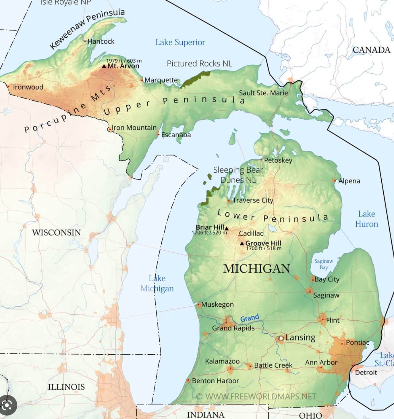
Judging from the map of Michigan you showed us, you’re trying to create topographic relief maps in a vector program — correct? If so, it seems you’ve already discovered that the mesh feature in whatever software application you’re using isn’t well-suited for the job. I’ve seen people do it, but it becomes extremely complicated with hundreds of shapes and meshes on hundreds of layers. I certainly wouldn’t attempt it.
Instead, more capable and specialized GIS (geographic information system) software is far better for this sort of thing — ArcGIS Pro, Surfer, or Mapitude, for example.
Unfortunately, these tools aren’t cheap and have a significant learning curve. In addition, they’re designed to take advantage of GIS data from much more expensive software, such as ESRI.
Judging from your question and if I understood correctly, it just might be possible that you’re trying to bite off more than you can chew at the moment. Even so, look at the links above and search YouTube for basic how-to tutorials on using this kind of software to give you a better idea of what’s involved.
Yes, I use that for reference. Also purchased a file. Because I’m creating maps as a product, I’ve been meticulous in following copyrights. I even consulted an attorney for proper labeling: “an artistic interpretation of cartographic facts.”
Thanks for your help. I’m using Illustrator and it’s important to note the map I attached is just a sample to show basically what I’m trying to do. I’m trying to colorize a map that artistically (think general, not accurately) shows relief. Emphasis is on the art. This map will not serve as educational reference.
In fact, let’s get away from the idea of topography and focus on colorization. Does anyone have ideas for adding various colors to a many-pointed vector shape in Illustrator?
This will be a professionally printed, hardcopy map.
Thanks all who have replied. I realize I’ve been vague with my question and that’s simply because I have nothing created yet to show you. Here are examples of maps I’ve previously done. This new map will be similar, however it’s to be done in a multitude of colors, as shown in the Michigan map (however, not these colors and not Michigan). Again—artistry is key.
The reason I asked if it would be printed is because at that point it doesn’t need to be vector as a final file. You could potentially use vector shapes with a blur effect layered on top of your map you could even paint layers on top of it in something like Photoshop.
Also, while gradient mesh could get complicated, if your “base map shape” is a solid color, you could create multiple gradient mesh shapes over varying ares or regions to provide more detailed gradient shading.
I would put a big rectangle that surrounds the map outline on a layer behind, and work the gradient mesh (and/or freeform gradient) as a fill of that shape (with the map outline locked but in view), then apply the map outline as a clipping mask.
If all you need are rough, non-scalable, artistic approximations for print, I’d probably move the vector outline into Photoshop to use as a guide. On a separate layer (or layers), I’d use whatever tools seemed appropriate to add the not-too-specific background details.
Since those details wouldn’t need to be especially sharp, the resolution wouldn’t even need to be especially high.
When I got it looking the way I wanted it, I’d place the relief map layer into Illustrator or InDesign and position it behind the vector data.
By the way, you’ve created some nice-looking poster maps. I can easily imagine one of those hanging on my wall if it showed my home state.
If you want to colorize your detailed vector map with a variety of colors, you might want to try the “Live Paint” feature in Adobe Illustrator. This allows you to easily apply colors to different areas of your map by simply clicking on them with the Live Paint Bucket tool. You can also adjust the colors later on and make sure that the accuracy of the outline is preserved.
This topic was automatically closed 365 days after the last reply. New replies are no longer allowed.